All entries for October 2013
October 23, 2013
Tracking the data trail of 'Spatial Humanities'
Following an excellent introduction to GIS and corpus linguistics in the Spatial Humanities project through this week's working lunch (storifyed here) with guest speaker from Lancaster, Ian Gregory. I enjoyed the way he sharing the process of getting from the text to the maps that could tell a visual story. Mapping the Lakes: A Literary GISminisite for project will show you the results.
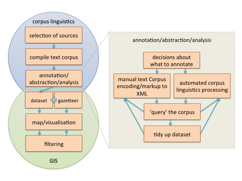
I know many in the room were keen to know what is actually likely to be involved. I felt that a visual recipe or workflow of how you bring the corpus linguistics and geography disciplines together in this way would be helpful in order to see at a simplistic level, what steps are involved. Having not yet done any of this myself, this is an observed workflow from what I understood from Ian's project. Doing this, I felt somewhat uneasy in simplifying what is evidently often an iterative and exploratory process.
Each of the steps identified is in itself a sub-process (or collection of) with decision points and often multiple routes and tools that could be applied. Some of these may be the topic of further exploration. I have pulled out one example with annotation/abstraction/analysis as an example. And this one can indeed be broken down yet further.
 Steve Ranford
23 Oct 2013 11:14
|
Steve Ranford
23 Oct 2013 11:14
| ![]() Tags: Geography Gis History Mapping XML
|
Tags: Geography Gis History Mapping XML
|  Comments (0)
|
Comments (0)
|  Report a problem
 Please wait - comments are loading
October 16, 2013
Have you heard about? The Casebooks Project
Writing about web page http://www.magicandmedicine.hps.cam.ac.uk/
What is my disease? Am I pregnant? Will I die? These are the sorts of questions that thousands of people asked Simon Forman and Richard Napier, two of the most popular astrologers in early modern England. Through four busy decades, Forman and Napier recorded approximately 80,000 consultations. Their casebooks are one of the most extensive surviving sets of medical records in history. They provide a unique view of the lives of ordinary — and extraordinary — people four centuries ago.
And, thanks to the casebooks project, funded by the Wellcome Trust and supported by the Bodleian Library and Cambridge’s Department of the History and Philosophy of Science, these will all be made available online in a format which is both browse-able and searchable. For those who are new to the genre of early modern casebooks, a guide to reading the texts is provided- discussing everything from the editing conventions utilised to the taxonomy under which the records have been sorted and categorised for searching.
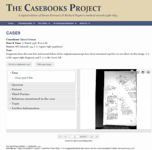
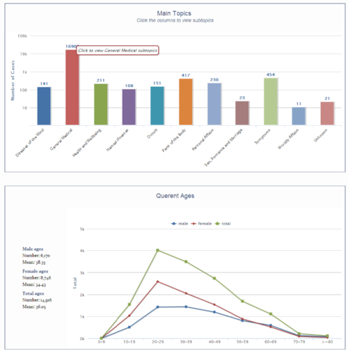
The interface, while not the easiest to use, provides a lot of detail regarding each case as well as a zoomable-image. Summary, or statistical, data is also available on a few clicks:
As with an increasing number of Digital Humanities projects, the website also includes a section “on astrological medicine” providing a rounded guide to the topic as well as a valuable bibliography for those who wish to read around the topic.
If you are interested in a similar project, get in touch with the Digital Humanities team and see how we can assist.
David Beck
16 Oct 2013 09:41
| ![]() Tags: History Manuscripts Wellcome Trust
| Comments (0)
| Report a problem
Tags: History Manuscripts Wellcome Trust
| Comments (0)
| Report a problem
October 02, 2013
Have you heard about? The Down Survey of Ireland
Writing about web page http://downsurvey.tcd.ie/
The website is the major output from a project funded by the Irish Research Council under its Research Fellowship Scheme, which ran from 1 October 2011 to 31 March 2013. First, surviving copies of county, barony and parish maps were identified and digitised. Then, they were combined with nineteenth century OS maps and twenty-first century satellite images (from google earth) to provide a multiple-scale seamless map of Ireland
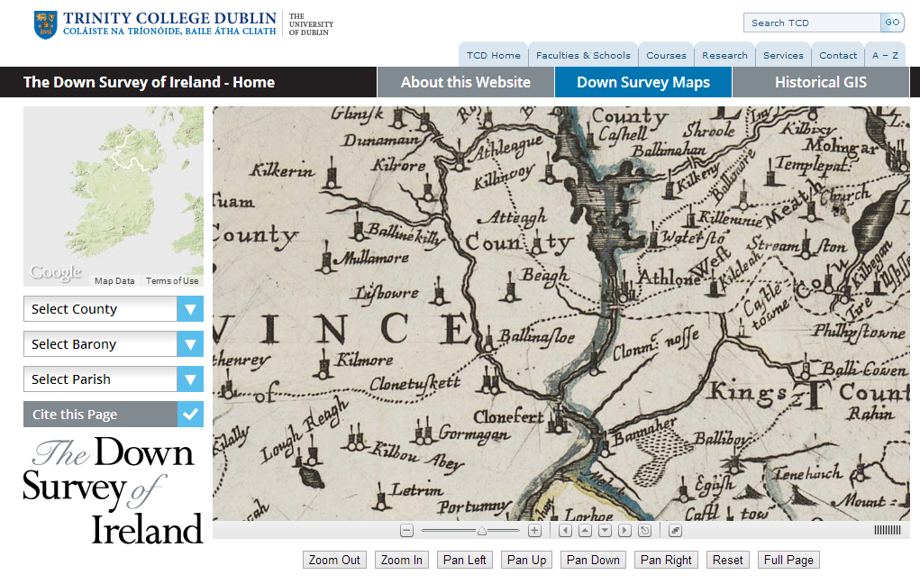
These digitised maps provide the backbone of the project, and are a resource in themselves, but to my mind the most interesting thing is the data that has been overlaid onto them from sources such as the 1659 census and 1641 depositions (which have themselves been transcribed and digitised- http://1641.tcd.ie/). This, as in the example below, allows us to “see” land ownership by religion in 1641 and 1670:
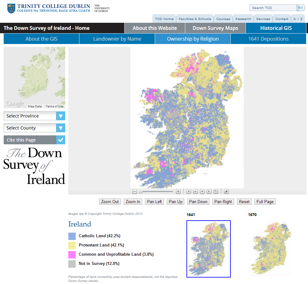
Basically, it’s a great example of what Historical GIS can do.
And for the technophiles among you- the sections on Historical GIS (http://downsurvey.tcd.ie/historical-gis.html) contain an admirable amount of information both on the construction of the dataset and the user interface.
If you are interested in a similar project, get in touch with the Digital Humanities team and see how we can assist.
David Beck
02 Oct 2013 09:16
| ![]() Tags: Geography Gis History Mapping
| Comments (0)
| Report a problem
Tags: Geography Gis History Mapping
| Comments (0)
| Report a problem
 Loading…