Travel Report: Big skies into Cape Town
Follow-up to Travel Report: Bathtime in the Western Cape from Transversality - Robert O'Toole
I could imagine the Atlantic to the west, a fiercely constant and cold generator of weather and fate, as I descended the N7 from Citrusdal, down towards the Cape. Imperceptibly the trickle of tarmac, eroding at the edges, filled out with the signs of approaching civilization. At some point a hard-shoulder emerged as the bush retreated. The road markings became more distinct. The rustic padstaals were displaced by modern service stations of international quality. But despite all of this, a geographical and meteorological sense kept me in my place: Africa, being funneled down to its point of disappearance, the Cape of Good Hope, with the turbulence of the cross-wind from the west hitting the mountains to the east. And me on a small bike being bounced around my path, fighting to keep moving on the desired line.
At around the half way point I pulled across the road and into a whole new world: a smart new Caltex station with a Wimpy restaurant and an extensive convenience store. I went straight to the Wimpy. My need for liquid was greater than that of the bike. Riding through such hot dry wind has a dehydrating effect, and I had found that I could go for only half an hour before stopping for a drink. I bought a big cold glass of guava juice, and wandered up and down in front of a TV showing cricket. Returning to the bike, I found a couple of boys inspecting it closely. The usual questions followed, which were however not met with the usual wonderment. It seemed that for any given feature of either the bike or the journey, daddy could do better. For the required evidence, they pointed to a new luxury 4×4 with a trailer full of quad "bikes". At which point, if I could have been bothered, two-wheel-only snobbery could have been my response, there being neither skill nor adventure in such a leisure pursuit. Daddy actually turned out to be not so bad. In fact with typical South African hospitality he gave me his business card and invited me to ride on his dirt track sometime.
Back onto the highway, a little further along, the restaurant and the rich white kids were easily forgotten. I descended a gentle hill and entered a wide plain. The sky darkened ahead of my direct path. Evidence of a rain storm was obvious on the horizon. To the west I could see a gap in the weather. And then further again to the west more rain. The regions of rain and shine were so distinct as to resemble a weather map, but viewed in three dimensions from below. My summer motorcycling clothes, including a Taureg desert jacket, now promised to be inadequate. I hadn't packed even lightweight waterproofs, having expected to be riding in the Western Cape dry season. However, rain at Algeria, Brandvlei, Vanrhynsdorp and Baths had taught me that this was no normal season.
I anticipated a soaking for what seemed like half an hour. It would not be too bad, I decided. In this climate rain might even be enjoyable, although I was nervous of how it might affect the Metzeler Sahara tyre on the front wheel. And then just as I had settled on the benefits of the wet, the road turned to the west, with a degree of determination heading for the gap in the weather. Rainstorms sat on the horizon of my peripheral vision whilst my view far along the road struggled with a dazzling light.
After some time riding along this trajectory, a vast flat-topped grey shape appeared in silhouette far away.
This and many similarly grand geographies represents a third of what attracts me back again and again to Southern Africa. A second such proportion of this fascination includes the complex fine detail of the land when experienced in close-up: the people, wildlife (big and small) and the plants. The third portion consists of the irreducible convulsions and foldings between these two scales, the grand and the miniature, the geological and the personal: the eruptions of chaos and senselessness that form the history of the land as people adapt to or resist its flows and formations. My journey had worked on all three of these scales. Now my passage through the wide plains and their weather, with Table Mountain as its growing focus, acted to draw the details of these events out into my memory, giving time and space for it all to negotiate some kind of settlement as the journey.
Of course I cannot claim that my small meander was much of a diagram connecting and carrying with it a multitude of diverse points spanning a whole continent. But I do think that even a small abandonment to the laws of deterritorialization is worthwhile as a means of thinking through space and time (call it geophilosophy). This may not have been possible if it were not for the far more extensive travels, adventures and ideas of another motorcyclist and writer. And as Table Mountain grew in scale, I paid homage to that journey:
My joy is almost hysterical as I park the bike, walk slowly over the paving towards a cafe table and sit down. I have just ridden that motorcycle 12,245 miles from London, and absolutely nobody here, watching me, knows it. As I think about it I have a sudden and quite extraordinary flash, something I never had before and am never able to recapture again. I see the whole of Africa in one single vision, as though illuminated by lightning. And that's it. i've done it. I'm at peace. (Ted Simon, Jupiter's Travels, Penguin 1990, p.183)
…uncountable and irreducible points across a continent connected in a single moment, a single line or diagram of deterritorialization.
The highway doubled in size. Traffic grew slightly more angry and urban. The N7 became the N1. And finally I reached the Cape Town waterfront for a rest.
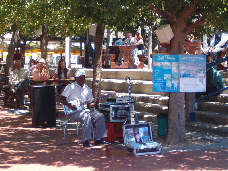
I found a drink and a lively crowd listening to a guitarist outside of the great shopping mall on the Victoria and Alfred Waterfront. At first I assumed that he was a busker. Only later did I discover that he manufactures unique electric guitars out of old drinks cans, for sale expensively in the V&A craft market.
But the journey didn't end there. With three days left, I had more points to connect.

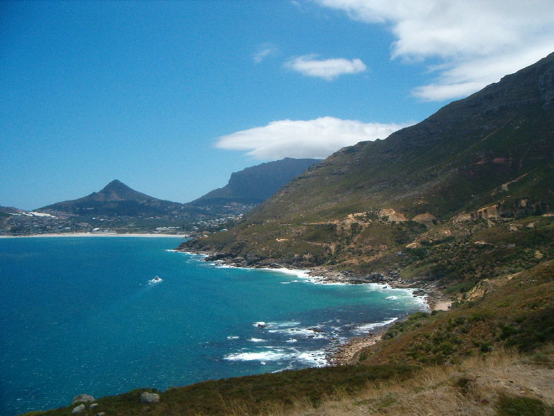
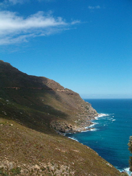
After half an hour's rest, I was back on the road to cross the Cape peninsula for Simon's Town. To get there I followed the coastline heading south along the west. I passed luxurious hotels and busy beaches packed with bathers and policemen. The water already looked an unreal shade of blue. The colour and sense of disbelief deepened as I rode upwards and onto the coast road known as Chapman's Peak Drive. This is unarguably one of the world's great roads. Between Noordhoek and Hout Bay, with the Lion's Head mountain and the ocean as its backdrop, it rolls through 114 curves in 9km. And all the time it clings to the edge of a cliff. Recent improvements have seen the implementation of a toll, but as usual the official waved me through. I stopped at several of the vantage points, with sports bikes and pedal cyclists whizzing past behind me as I looked out into the bay.
Magnificent. See a video of Chapmans Peak Drive on this site.
Once through to the other side of the drive, I crossed the peninsula to Simon's Town.
Part 8, Boulders Beach in close up
 Robert O'Toole
11 Feb 2006 23:34
|
Robert O'Toole
11 Feb 2006 23:34
| ![]() Tags: Bmw Gs Motorcycle Travel South Africa Travel Travel And Motorcycles Travel Writing Writing
|
Tags: Bmw Gs Motorcycle Travel South Africa Travel Travel And Motorcycles Travel Writing Writing
|  Comments (0)
|
Comments (0)
|  Report a problem
Add a comment
You are not allowed to comment on this entry as it has restricted commenting permissions.